The short and sporty via ferrata Jerm`n can be a good introduction to the D/E grade for people already confident on D level via ferratas.
Summary
Grade: D/E – view topo
Vertical: 110m ferrata, 140m total
Time: 10min approach, 30min ferrata, 30min descent, 1h10min total
Access / Parking: 46.4846,13.8427 – Google Maps or any Android maps app
Start via ferrata: 46.4872,13.8419 – Mapy.cz or any Android maps app
Download gpx track
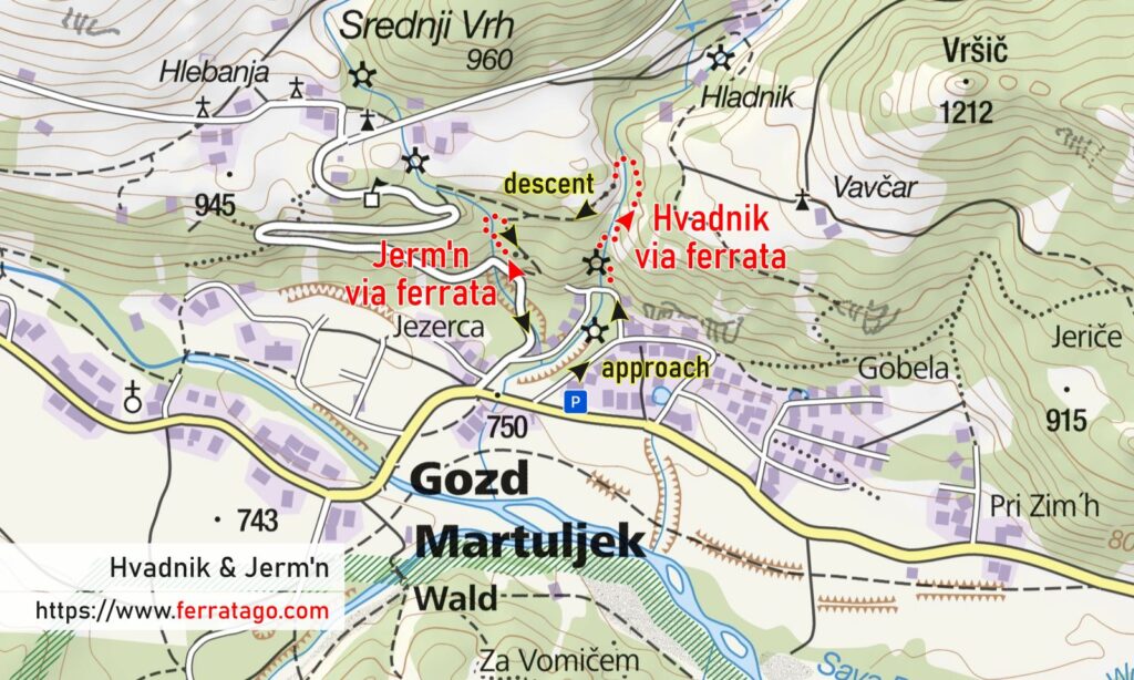
Map

Access
Situated between Kranjska Gora and Mojstrana / Jesenice, we arrive in Gozd Martuljek on road 201. This settlement once called Rute is well connected with the nearby towns by a nice bike path, separated from car traffic.
Approach to start
The short approach starts at the paid parking lot near a sports ground and is well marked with signs. If you are camping at nearby Kamp Špik, you can start the approach on foot from there, with similar times.
The route
It starts with a proper vertical D segment. After it, you already have an emergency exit or continue and cross a suspension bridge before moving up on the next vertical section, which contains the slightly overhanging D/E segment. Keep in mind that you need good friction to advance on some segments, so avoid going up when the rock is wet, if possible.
Descent
Follow the marked trail back to start. If you go upwards from the end of the cable, you can reach the Brunarica Krmiše hut, situated on a meadow, a good place to take a break.
Good to know
- It takes a couple of days for the route to dry out after rainfalls.
- You can combine this route with the longer but easier Hvadnik via ferrata, in the nearby gorge.
- Inaugurated in July 2019.
Donation box
I’m trying to keep this site ad free, supported by donations only via Buy Me a Coffee, PayPal or Bitcoin. Your support is highly appreciated.
Video
Weather
Main sources
- bergsteigen.com (German)
- tadejatravels.com (Slovenian)
- we climbed the route on August 5, 2022

Is there a place nearby (Kranska Gora?) where we can rent equipment for via ferrata (harness, carabiners, slings, helmet)? We are traveling from Canada and have no room to bring our own equipment?
Claude from Montreal
Yes. You could rent via ferrata gear in Mojstrana, from either the Slovenian Alpine Museum or Kofler Sports. Call or email ahead of time. While you’re there, you could climb the via ferratas in Mojstrana too :).
I personally like my via ferrata set, so I would try to add it to the airplane luggage, along with a set of gloves, and only rent a harness and a helmet.