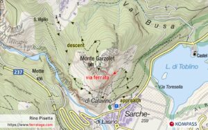
Rino Pisetta is an airy, exposed, challenging and technical via ferrata built in 1982 on the walls of Cima Garzolet, offering views over Castel Toblino and lake Toblino. With polished rock holds, it is a good challenge for E level climbers.
Summary
Grade: E – view topo
Vertical: 430m ferrata, 715m total
Time: 45min approach, 2h45min ferrata, 1h30min descent, 5h total
Access / Parking: 46.0476,10.9510 – Google Maps or any Android maps app
Start via ferrata: 46.0526,10.9521 – Mapy.cz or any Android maps app
Download gpx track
Map and photos


Access
You start in Sarche village. The parking coordinates above are for a place indicated on signposts as parking for Rino Pisetta, near an elementary school and a football field. Alternatively, you can park in one of the parking lots in the village center.
Approach to start
The approach trail is marked, but a navigation app with offline maps does not hurt here either and it will be useful on the descent as well. Following this marked trail, you hike for about 45 minutes and gain 300 meters vertical distance. The last part of the approach is a rock scramble, on alpine terrain not secured with cables.
The route
One of the hardest segments of this route can already be seen from the start – if you struggle with this section, you can use the emergency exit on the right, just after this E segment.
Here we understand quickly the type of climbing required for this route, on polished rock holds with very few artificial rungs. If you enjoy rock climbing, you’ll enjoy this route as well, as it is easier to climb when you take your time and find the right natural holds to use.
The route has various vertical segments, traverses, some cracks and chimneys.
Mid-route there’s another hard segment, with very good hand holds on the left edge.
Below the final ridge, the cable stops and you continue on a path until you connect with the next segment of the route.
At the very top you’ll find a bench, a Madonna statue and a picture of Rino Pisetta, a mountaineer from Trentino who died in a road accident on his way back from the Dolomites. He was the creator and actively participated in the construction of the via ferrata which today bears his name.
Descent
From the summit Garzolet (961 m) we follow the marked path to Ranzo. Just before Ranzo, we find drinking water in a picnic area. Shortly after, on our right there’s a bar with a terrace, then we arrive at a signpost on the road.
We can go right on the long 613 trail back to Sarche, which is displayed on the sign pole, but we’ll describe the shortest descent which is left, towards an intersection with a cross, where we turn left again towards a small chapel.
At the chapel there should already be signs pointing to Sarche, sometimes painted on rocks.
The navigation app we mentioned in the approach would come in handy here as well, as we continue on a service forest road, from which a path branches off at a bend. We follow this path and the Sarche markings we see occasionally.
One more section will prove challenging: a series of exposed steps secured with a cable.
This long path from Ranzo ends with steep switchbacks in the forest, just above the parking lot in Sarche.
Good to know
- Can be climbed year long, due to the warm climate, but can be very hot during Summer, so bring enough water with you.
- Not recommended when wet because the holds are already polished as it is.
- Built in 1992.
Donation box
I’m trying to keep this site ad free, supported by donations only via Buy Me a Coffee, PayPal or Bitcoin. Your support is highly appreciated.
Video
Weather
Main sources
- bergsteigen.com (German)
- ferrate365.it
- we climbed the route on August 2, 2023

hi there
we are group of 10 peaple and we need a guide to lead us this via ferrrata can you help us with this
Hi! Rino Pisetta is a serious route. Make sure all people in your group are well prepared for it, with several D and D/E routes done previously. I don’t know any guides in that area, but at the bottom of this page, ferrate365 recommends a few guides.